Client Challenge
Our client was engaged in a large-scale negotiation involving over 150 sites across the country. A key challenge was ensuring accuracy in GIS boundary data by identifying discrepancies between Land Registry boundaries and their own records. Initially, the client requested compliant plans for all sites, but our analysis revealed that a more tailored, efficient approach was needed to achieve their objectives.
Our Approach
Step 1: Tailored Mapping Solutions
Rather than simply producing compliant plans, we identified an opportunity to enhance clarity and usability through customised illustrative maps.
- Instead of relying on multiple separate documents, we recommended a consolidated visual approach to display boundary changes clearly.
- This method allowed the client to quickly compare and assess differences, streamlining decision-making during negotiations.
- Based on the success of this approach, the client adopted illustrative maps as the preferred method for the entire project.
Step 2: Data Extraction and Segmentation
With the mapping approach refined, we proceeded with detailed GIS data extraction:
- The client provided a master shapefile containing boundary data for all sites.
- We extracted individual GIS information and created separate shapefiles, enabling precise, site-specific mapping.
- This process ensured that each map was both accurate and easy to interpret.
Step 3: Iterative Comparison and Analysis
As negotiations progressed, title information and boundary updates were exchanged between buyer and seller legal teams. To maintain accuracy:
- The client sent updated master shapefiles, which we used to conduct spatial comparisons.
- By analysing polygon geometry, we identified discrepancies in points and nodes between datasets.
- Any changes were flagged and reported for client review, allowing for continuous refinement and ensuring data integrity. (Reported both visually and in written format).
Step 4: Boundary Confirmation and Additional Services
Once the client confirmed the refined boundary data:
- We applied for SIM (Search Index Map) searches on their behalf, streamlining an essential step in their workflow.
- This proactive approach ensured a seamless integration of updated data into their ongoing negotiations and decision-making processes.
Illustrative Example To help visualise the kind of mapping solutions we provided, we have created a sample illustrative map of five castles located around the country. This example demonstrates how before-and-after representations can be overlaid within a single resource, removing the need for multiple documents. By using this method, users can quickly and clearly see visible differences—just as our client did during their negotiations. This type of resource is part of our bespoke service and can be tailored to suit various project needs. You can view the sample Illustrative Map here: Illustrative Map 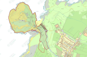
Results and Impact
- Enhanced Accuracy – Our spatial comparison process effectively identified and resolved boundary discrepancies, ensuring data integrity.
- Improved Clarity – Custom illustrative maps provided a clear, user-friendly representation of site boundaries, aligning with the client’s needs.
- Optimised Workflow – The iterative approach enabled seamless updates, minimising delays and maximising efficiency.
- Added Value – By rethinking the client’s initial request and proposing a more effective solution, we delivered an outcome that exceeded expectations.
Conclusion
This project highlights the value of adaptive problem-solving in GIS data management. By introducing customised mapping solutions early in the process, we provided the client with a more effective and efficient approach to managing their large-scale project. Our bespoke service—including the ability to create consolidated, overlay-based illustrative maps—ensures that clients can access clear, actionable insights without the burden of managing multiple documents. Our commitment to accuracy, clarity, and workflow efficiency ensured that they remained in full control throughout complex negotiations.
——————————————————————————————————
Want to find out more about the tools and services used?
 Portfolio Service: Our dedicated portfolio team focuses on accuracy and efficiencies, whilst ensuring excellent communication is delivered by an experienced and knowledgeable team. Find Out More
 REI (Real Estate Intelligence): A tool that not only reads and summarises the results of Local Authority searches but also provides an extract of the data in a standardised format. Find Out More
Request a REI sample extract here
REI (Real Estate Intelligence): A tool that not only reads and summarises the results of Local Authority searches but also provides an extract of the data in a standardised format. Find Out More
Request a REI sample extract here